Waipuilani Mauka: Waipuilani Mauka is a large ephemeral wetland area dominated by Kiawe and scrub shrubs. It is an original wetland that has remained undeveloped. Over time this area has been surrounded by developments and the hydrology has changed. In general, Hawaii is getting drier, and storms are getting stronger. Climate change, droughts, invasive plants, and over-development has put these types of scrub-shrub wetlands in poor condition. However, the aquifer remains strong and water continues to flow under the surface. This wetland is subject to rising and falling water tables and is expected to play an increasingly important role as we experience ongoing SLR.
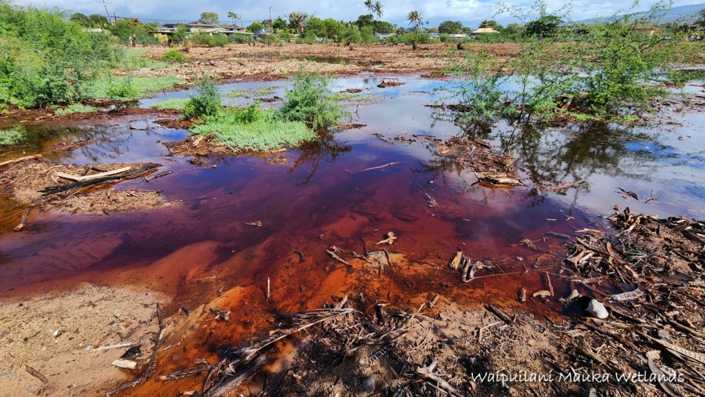 Waipuilani Mauka Wetlands Kihei
Engineering: The gulches above these wetlands have been heavily engineered, and watercourses have been moved to go around or even underneath housing developments. High above Waipuilani Mauka is an unused 50-foot-acre detention basin, and there are plans to fully divert the local watershed over into another gulch. This kind of engineering has been devastating to the environment and radically alters the functionality of the Watershed. This site shows many of the obvious signs of wetland hydrology such as altered vegetation, mud areas, loose silty soil, and extensive salt-crusted areas, and other indications of pooling waters. This site is most active during rains and has the ability to hold vast quantities of stormwater.
 Waipuilani Mauka
Site Vulnerabilities: Waipuilani Mauka also lies within the wetlands Study Zones of Kolb 1965, Erickson 1991, and now Stw 2021. It also lies within the Maui County Special Management Area (SMA), Coastal Management Zone (CMZ) and the 3.2ft SLR Coastal Hazard Zone. This area and its neighboring sites are becoming increasingly vulnerable to the Coastal hazards due to the effects of Sea Level Rise.
Coastal Hazards due to SLR: As early as 2060 a 3.2ft SLR will put this site within the reach of high waves and coastal inundation due to storm surges, and many of the smaller tsunamis.
 Waipuilani Mauka
The Waipuilani Mauka Wetlands, located in Kīhei within the Moku of Kula, represent a significant natural habitat in South Maui. This expansive area is characterized by its original wetland ecosystem, which has remained undeveloped over the years. The landscape is predominantly covered with Kiawe trees and various scrub shrubs, contributing to its unique ecological composition.
Historically, the coastal plain of North Kīhei was dotted with numerous active wetlands, making it prone to frequent flooding and serving as a vital habitat for diverse wildlife. The Waipuilani Mauka Wetlands are part of this larger network of wetlands that once thrived in the region.
These wetlands play a crucial role in the hydrological process, facilitating the flow of water from the mountains (mauka) to the sea (makai). The Waipuilani Gulch Wetlands, for instance, exemplify this natural watercourse, highlighting the interconnectedness of the area’s watershed systems.
In recent times, the importance of preserving such wetlands has gained attention due to their ecological significance and the ecosystem services they provide. Efforts are underway to map and protect these sensitive areas across Maui, Molokai, and Lanai, aiming to mitigate flooding, control harmful runoff, and enhance biodiversity.
The Waipuilani Mauka Wetlands, along with other nearby wetlands like the Lāʻie Wetland, form an integral part of South Maui’s natural heritage. Collectively, they contribute to the ecological health of the region, supporting various species and maintaining the balance of coastal ecosystems.
Preserving the Waipuilani Mauka Wetlands is essential for maintaining the ecological integrity of South Maui. These wetlands not only support biodiversity but also play a vital role in water management and environmental stability in the region.
The following image shows the proximity and association of Waipuilani Mauka and the local wetlands group.
 Waipuilani/Kawililipoa Wetlands Group